
Information
ESA, together with the National Remote Sensing Centre of China (NRSCC), an entity under the Ministry of Science and Technology (MOST) of the P.R. China, have cooperated in the field of earth observation application development for more than 15 years. In 2004 a dedicated three year science and exploitation DRAGON programme was initiated in 16 priority areas using ESA ERS and Envisat data in P.R. China.
Within the follow on programme DRAGON 2 the cooperation has been enlarged to 25 projects exploiting ESA, TPM and Chinese EO data for land, ocean and atmospheric science and application development in P.R. China. The programme will last for 4 years and will finish in June 2012. The expected benefit and contribution is to:
- Promote the use of ESA, TPM and Chinese EO data for science and application development
- Stimulate scientific exchange in EO science and application by the formation of joint Sino-European teams
- Publish co-authored results of the research and applications development
- Provide training in processing, algorithm and product development from ESA, TPM and Chinese Earth Observation data in land, ocean and atmospheric applications
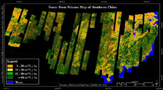
Fig. 1: ERS-1/2 tandem coherence stem volume map 1995/98
One project within the DRAGON 2 programme is called Forest DRAGON 2. Due to the fact that Chinese forests have been ongoing constant pressure and existing forest resources are not considered adequate for needs of the Chinese economy and livelihood of people, the Forest DRAGON 2 project aims to monitor the Chinese forests status and development on a regular basis by using Earth Observation data. These data provide an appropriate tool which enables to consistently monitor forest cover and forest cover changes. It allows the identification of environmental and socio-economic impacts and the development of indicators for assessment approaches.
During the Forest DRAGON 1 project (2004 – 2008), forest growing stock volume (GSV) maps were produced with four GSV classes for Northeast (~1.5 Million km²) and Southeast China (~3 Million km²) at 50 m spatial resolution from ERS-1/2 tandem coherence data (Fig. 1).
Within in the Forest DRAGON 2 project these two maps will be validated and a validated 1995-2005-2010 forest structure change map will be created from GSV maps derived from ASAR data by using the BIOMASAR Algorithm (Santoro et al. 2011).